Ha Giang Travel Guide: The Loop, Best Time to Visit & Things to Do
Last updated: July 3, 2026
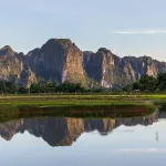
This Ha Giang travel guide is for the trip that ruins you a little for anywhere flatter — the far-north corner of Vietnam where the road climbs into limestone and the rivers turn an unreal shade of green. Ha Giang sits right up against the China border, about a day’s travel from Hanoi, and it rewards the effort of getting there. Come for the mountains. Stay for the markets, the buckwheat fields and the people who live at the top of the country.
Quick answer: Ha Giang is best for travellers who want dramatic mountain scenery, the famous Ha Giang Loop and a real taste of hill-tribe life. The best time to visit Ha Giang is the dry season, roughly October to April — with golden rice terraces in September and October, and pink buckwheat flowers in late October and November. Give yourself at least three to four days to drive the loop through Quan Ba, Yen Minh, Dong Van and Meo Vac, and don’t rush the viewpoints over the Nho Que River.
- Country: Vietnam (the far north)
- Best time: October–April (dry); Oct–Nov for buckwheat, Sep–Oct for golden rice
- Known for: the Ha Giang Loop, Ma Pi Leng Pass, the Nho Que River, Dong Van Karst Plateau Geopark, hill-tribe markets
- Good for: road trips, photographers, culture-lovers, adventurous travellers
In this guide: Things to do · The geopark · Best time · Culture · Food · Know before you go · FAQs
What are the best things to do in Ha Giang?
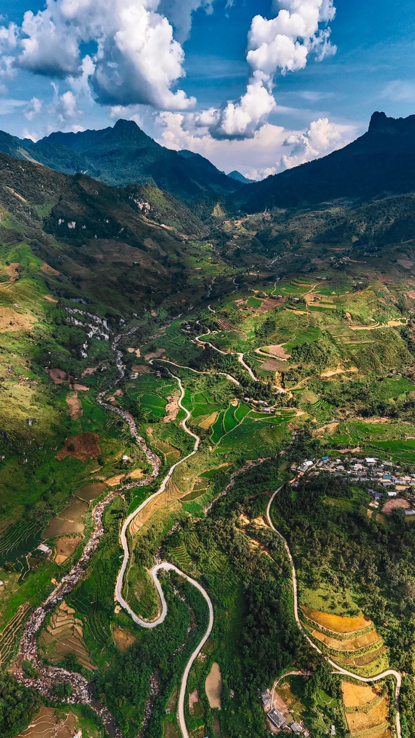
Start with the drive itself. The Ha Giang Loop is a roughly 350-kilometre circuit that most people ride or drive over three to four days, looping through Quan Ba, Yen Minh, Dong Van and Meo Vac. Every hour looks different — terraced valleys, stone-walled villages, switchbacks that make you gasp and then laugh. If you’d rather leave the driving to someone else, a guided Best of Northern Vietnam tour can fold the region’s highlights into a wider trip.
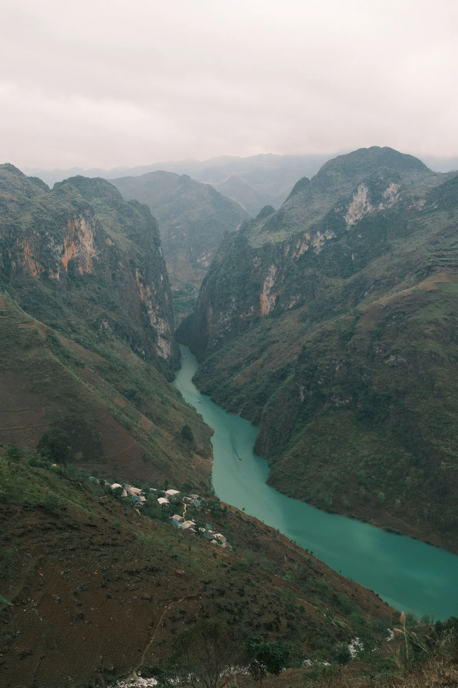
The headline stop is Ma Pi Leng Pass, one of Vietnam’s four great mountain passes. It runs about 20 kilometres between Dong Van and Meo Vac, and from the top you look straight down — a long way down — to the Nho Que River glowing turquoise in the Tu San canyon below. You can take a boat or kayak on the river itself, which is the calmest way to feel just how deep that gorge really is.
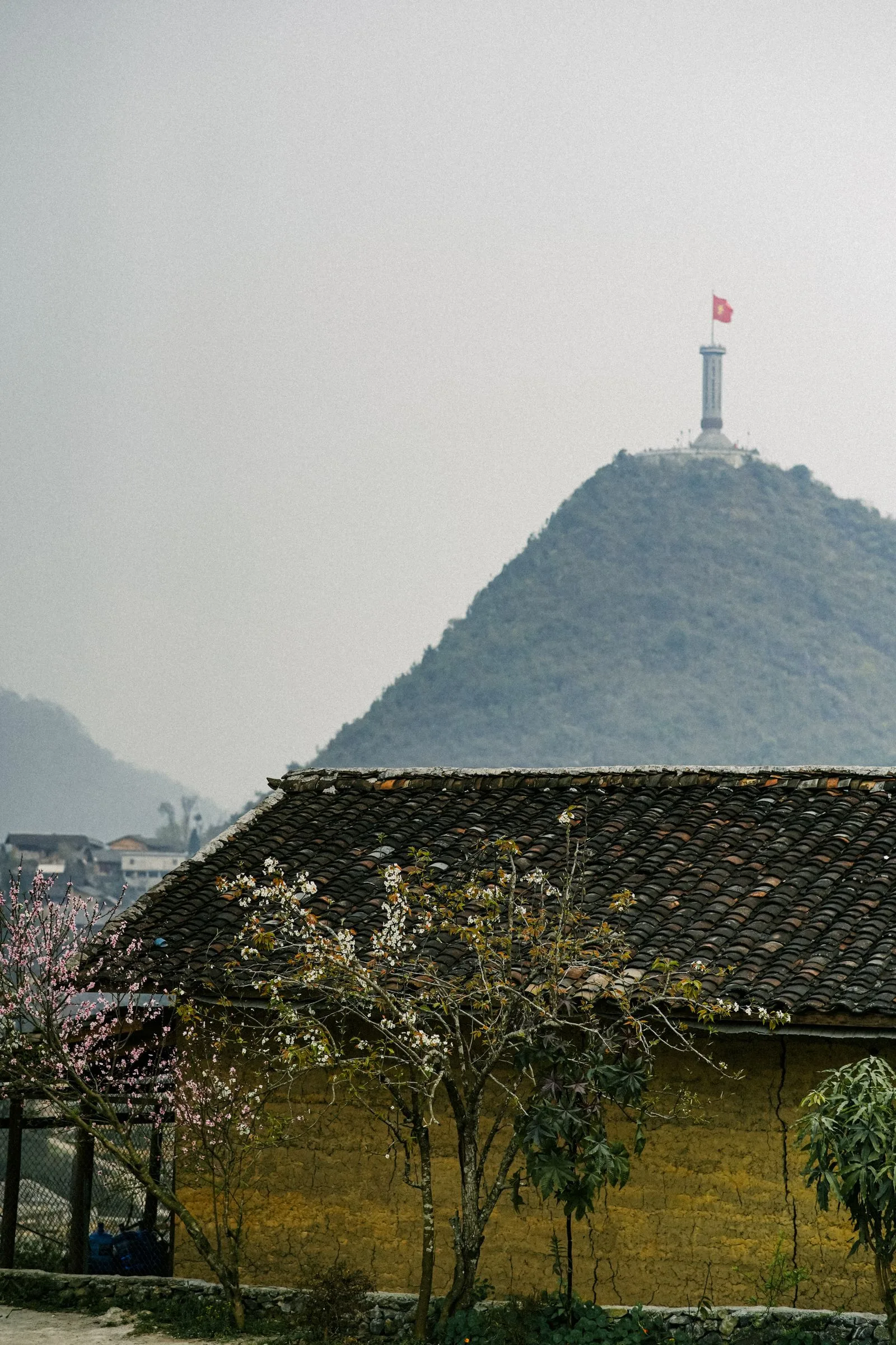
Further north, the Lung Cu Flag Tower marks the northernmost point of Vietnam. Climbing the steps to the big red flag is a small pilgrimage for local families, and the view spills right over the border hills.
Near Tam Son, in the Quan Ba area, don’t skip the Heaven’s Gate viewpoint and the Twin Mountains — two soft green hills the locals nickname the Fairy Bosom. It’s usually your first proper “oh” moment as you leave the lowlands behind.
A little history: the roof of Vietnam
Ha Giang has always been frontier country — a meeting point of ethnic groups and trade routes rather than one tidy story. The landscape is genuinely ancient. The Dong Van Karst Plateau was recognised by UNESCO as a Global Geopark in 2010, the first in Vietnam, for limestone that has been forming here for hundreds of millions of years.
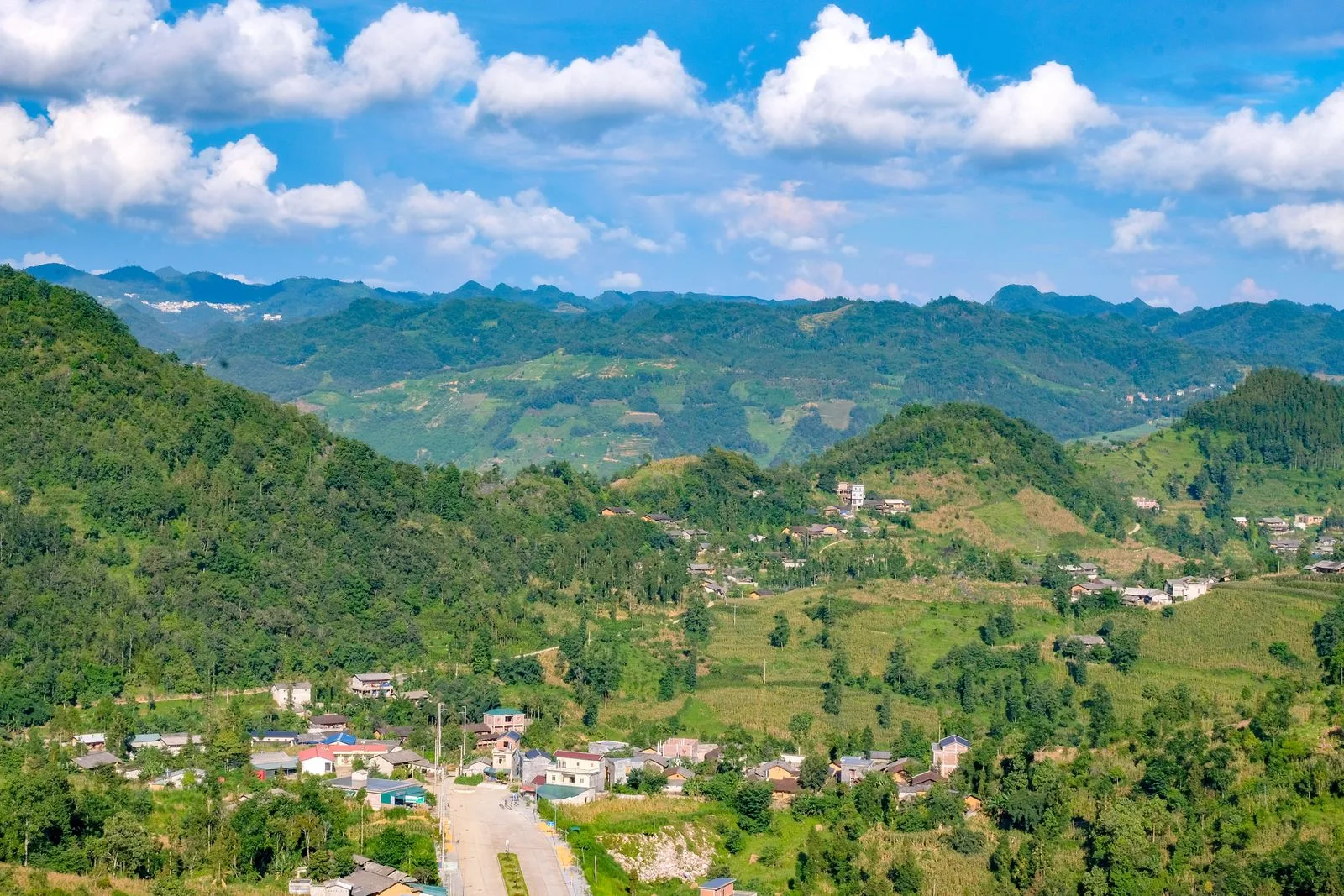
Up here, seventeen ethnic groups share the highlands, the Hmong, Tay and Dao among the largest. You see it in the architecture: earthen-walled houses with fish-scale tile roofs, stone fences stacked without mortar, and terraced fields carved into slopes that look impossible to farm. People have made a life on this rock for generations, and that quiet resilience is a big part of what you feel here.
When is the best time to visit Ha Giang?
The short version: the dry season, October to April, is the safest bet, because the loop’s mountain roads are far friendlier without heavy rain. But every season has its own reason to come.
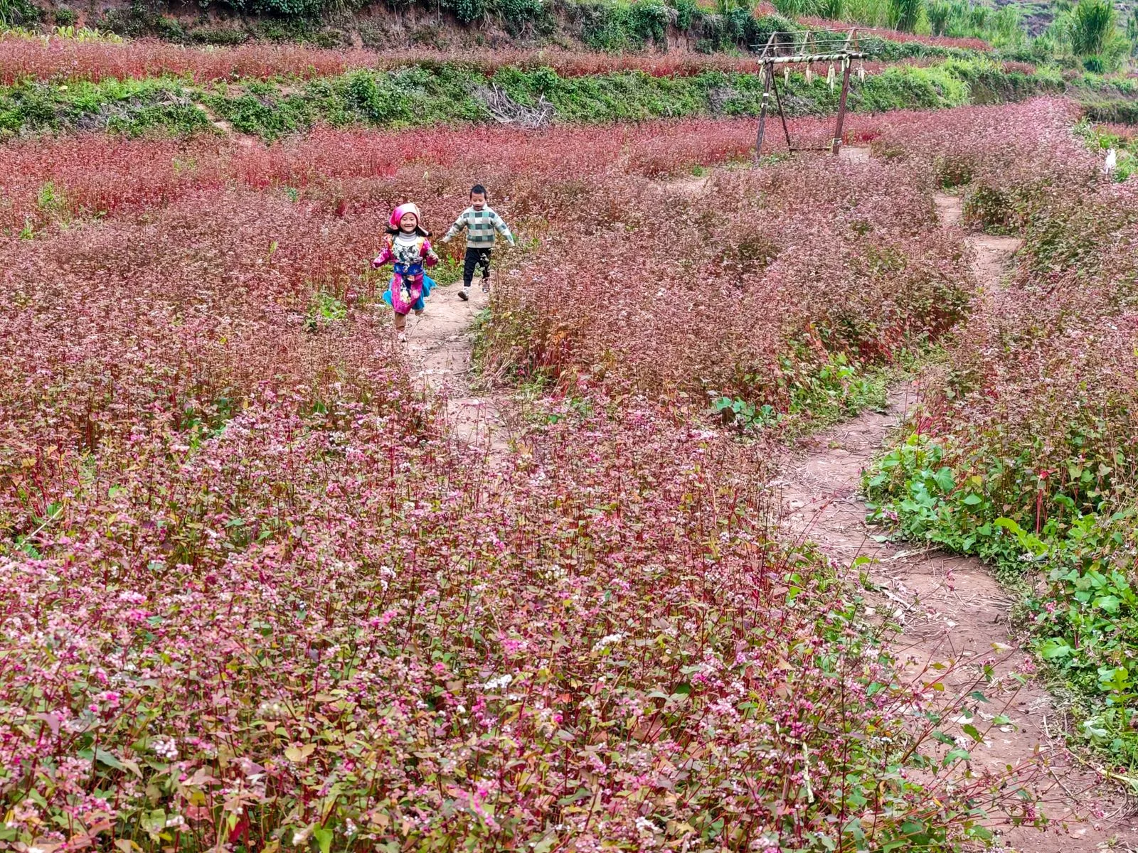
Autumn is the showstopper. Rice terraces turn gold around September and October, and then the pink buckwheat flowers — tam giac mach — bloom across late October and November, with a Buckwheat Flower Festival to match. Winter, December to February, is cold and misty up high, sometimes dropping below 10°C, but it’s atmospheric and quiet.
| Season | Weather | Good for | Crowds |
|---|---|---|---|
| Spring (Mar–May) | Mild, the odd shower, hills greening up | Blossoms, easier driving, fewer people | Quieter |
| Summer (Jun–Aug) | Warm, humid, heaviest rain | Lush green terraces (watch road conditions) | Quiet |
| Autumn (Sep–Nov) | Dry, cool, clear skies | Golden rice (Sep–Oct), buckwheat (Oct–Nov) | Busiest |
| Winter (Dec–Feb) | Cold and misty, can dip below 10°C | Moody scenery, late-season blossom | Quiet |
Whichever season you choose, a local guide takes the guesswork out of road conditions and timing. Our Luxury Northern Vietnam tour is one easy way to explore the north in comfort.
People, culture and etiquette in Ha Giang
The markets are the heartbeat. Dong Van and Meo Vac both hold their big markets on Sunday, and they aren’t staged for tourists — they’re where highland families trade livestock, textiles, tools and news. Go early. By mid-morning the best of it is already winding down.

A few gentle manners go a long way. Ask before photographing people, especially older women in traditional dress. Dress modestly in villages, slip your shoes off when you’re invited into a home, and if someone pours you a cup of corn wine, a small toast is the polite reply.
Culture note: Those tall back-baskets you’ll see everywhere — the gùi — carry everything from firewood to a whole market’s worth of vegetables. Buy a handful of produce from a stall and you’re not just getting a snack; you’re stepping into a trade that’s older than the road you drove in on.
What food should you try in Ha Giang?
Mountain food is hearty and made for the cold. Try thang co, a slow-simmered highland stew that’s a market-day tradition; men men, steamed cornmeal that stands in for rice up here; and au tau porridge, a warming bowl often eaten in the evening. Look out for smoky grilled river fish and, at festival time, five-colour sticky rice.
Half the fun is not knowing exactly what you’ll be handed. Ask your My Viva Tour guide for the best local spots — the tiny market stalls and family kitchens rarely have a sign, let alone a menu.
Ha Giang travel guide: know before you go
- Best time: Dry season October–April; autumn (Sep–Nov) for golden rice and buckwheat.
- Getting there: Ha Giang town is roughly 280–300 km north of Hanoi, about a 6–7 hour drive or overnight bus.
- Getting around: The loop is done by motorbike, by “easy rider” pillion, or by private car with a driver — the comfortable choice if you’d rather watch the view than the road.
- Permits: A border-area travel permit is required for the zones near the China border; a guide or hotel usually arranges it for you.
- What to wear: Layers and a windproof jacket — it’s cold and misty at altitude even when Hanoi is warm — plus proper shoes for muddy viewpoints.
- Etiquette: Ask before photos, dress modestly in villages, and go easy on the corn wine.
Ha Giang travel guide FAQs
Is Ha Giang worth visiting?
Yes — for mountain scenery, it’s arguably the most spectacular part of Vietnam. The Ha Giang Loop, Ma Pi Leng Pass and the Nho Que River draw travellers who want raw landscapes and genuine hill-tribe culture rather than polished resorts.
How many days do you need in Ha Giang?
Plan three to four days to drive the full loop through Quan Ba, Yen Minh, Dong Van and Meo Vac at a relaxed pace. Add a day at each end for the travel to and from Hanoi.
When is the best time to visit Ha Giang?
The dry season, October to April, gives the safest roads and clearest views. September–October brings golden rice terraces, and late October–November brings the pink buckwheat bloom.
Do you need a permit for the Ha Giang Loop?
Yes. A border-area travel permit is needed for the districts near the China border that the loop passes through. Guides, hotels and tour operators normally organise it for you.
What is Ha Giang known for?
The Ha Giang Loop, the Ma Pi Leng Pass over the Nho Que River, the Dong Van Karst Plateau Geopark, Lung Cu Flag Tower, and Sunday hill-tribe markets full of colour, corn wine and thang co stew.
Why Ha Giang stays with me
What stayed with me wasn’t the big viewpoint everyone photographs. It was a Sunday market before eight — the smell of thang co and woodsmoke, and an old Hmong woman who laughed out loud when I couldn’t lift her back-basket. Ha Giang doesn’t perform for you. It just gets on with its life at the top of the country and lets you walk beside it for a few days.
Over to you: what about you? If Ha Giang is already part of your travel story, tell me in the comments below — I’d love to hear what stayed with you.
See Ha Giang with My Viva Tour
Ready to plan it? Browse our Best of Northern Vietnam tour or our Wonderful Northern Vietnam trip, and read more of our Ha Giang travel stories. For a first-hand feel of the region, our earlier post The Journey to Discover Ha Giang is a lovely companion read, and if you’re mapping a wider Vietnam route, our Da Lat travel guide covers the cooler highlands further south. Tell us your dates and we’ll help you build the trip.
Travel notes fact-checked: July 2026.